The 3D/4D data display library for Contouring, Surface Mapping & X-Sections
GINOSURF is a multi-dimensional graphical display library providing a variety of surface representations. Contour plots, perspective surfaces and cross-sectional diagrams can all be generated to perform accurate visual appraisal of your multi-dimensional data. This impressive and high performance surface mapping can all be created with a minimum of programming effort.
Data sources include 3D or 4D, random or gridded datasets which are interpolated onto a gridded or triangulated network with full programmable interpolation control. Pre-triangulated data can also be input from FE triangulated datasets and DXF Polyface surface metafiles. Control routines provide full colour control, scaling, direction of viewing, character and annotation control, projection of contour slices, area fill of specified data regions, axis control and full hidden surface facilities.
Triangular Interpolation
GINOSURF can interpolate from functions, random data or gridded data, but as well as interpolating onto a rectangular grid as most other packages do, GINOSURF can interpolate onto a triangular network. A triangulation network may be generated from random (or gridded but treated as random) data from which contour maps, 3D surfaces and cross-sections may be drawn. Contouring through a triangulated network allows more precise tracing of a particular height value because the ‘route’ of the contour is evaluated by interpolating between the three nodes of each triangle which means only the ‘local’ values will affect the contouring. Interpolating onto a rectangular grid involves a larger number of surrounding points and can influence the tracing adversely. The triangulation network has the disadvantage of greater complexity, but has the advantage of offering irregular boundaries, faults, excluded regions and many additional control routines.
Contour Maps
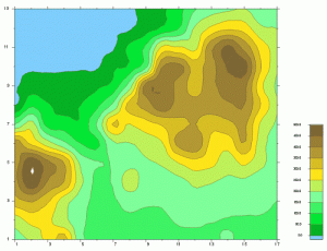
GINOSURF contour maps give you full control over all aspects of the map, either by accepting the default settings or customizing via additional parameters and routine calls. Contour maps can be displayed over the complete contour range of the data or just the contour levels you want to display on the map. You can choose a whole range of annotation settings for the axes or contours themselves and of course you can add colour fill between the contours to enhance the presentation quality.
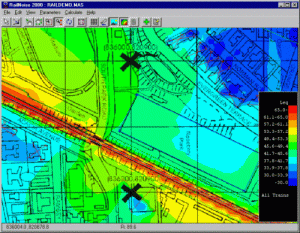
Contours overlayed on Image
A coloured contour map can easily be overlayed onto an existing image map giving accurate colour information directly relating to the image data. The image can be any one of the popular image formats including BMP, JPEG, WMF, PNG etc.
3D Projected Contours
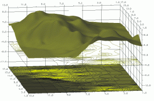
In addition to displaying contour maps as 2D drawings, they may also be projected onto a 3D axis system with or without an accompanying surface. They can be colour filled or line-drawn and the line-drawn variety can be optionally background filled beforehand if a transparency effect is not desired.
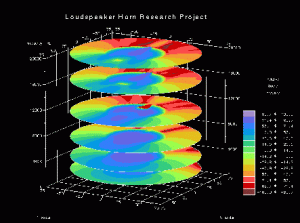
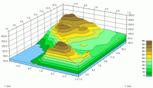
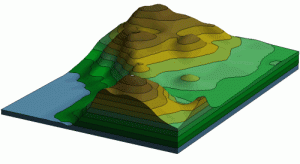
3D Filled Surfaces
3D surface maps can be shaded or filled to emphasize height related features. The surface can be viewed from any eyepoint and control is given over frame style, base style, annotation, height-base ratio, and display of surface line styles. Contoured Surfaces Filled surfaces can also be drawn with contour data overlaid so that the colour filling is controlled by the contour bands.
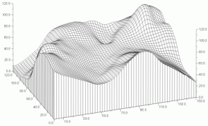
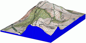
3D Wireframe Surfaces
Wireframe surfaces can be viewed and controlled in the same way as filled surfaces but can be used to give more a more accurate represention of the data being displayed. Wire-frame surfaces can be drawn with different coloured section lines that vary according to height.
3D Shaded Surfaces
Lighting and Shading can be applied to any type of surface map using the OpenGL facilities of GINO. Flat, Gouraud or Phong shading can be set together with up to 8 light sources including spot lights, directional lights or ambient lights.
Textured Overlays
Texture mapping can be applied to any filled surface allowing the draping of any size pixel map up to 1024 x 1024 pixels. The texture can be applied in overlay mode, modulate mode or blend mode, either replacing or merging with the surface colours respectively.
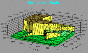
Faults and Breaklines
One or more vertical fault lines can be added to an existing 3D network. A fault line (or curve) is a vertical discontinuity in the surface, but to allow triangulation of the fault, it is displaced by a small amount from the vertical.
Break lines may be used to add surface details such as contours, ridges or buildings whether or not the heights of such features are known. The line segments are guaranteed to exist as edges of triangles in the new network and therefore where constant heights are supplied, contours will not cross the breakline.
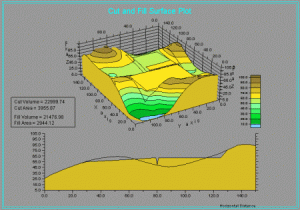
Cut and Fill Surface Display
Projected building site boundaries and slopes may be added to surveyed surface data to calculate and display cut-and-fill areas and volumes for the project. The site data is formed into an additional sub-surface from which the intersection with the true surface data is calculated. Separate areas and volumes both above and below the intersection are supplied along with the ability to display the site in-situ with the original surface.
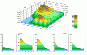
Cross-Sections
Two points on the base of a contour map or 3D surface can easily be used to draw a simple cross-section. The cross section can be wire-frame or colour-filled as per a contour map and the usual facilities of frame type, axes style, labels and annotation can all be controlled. A polyline cross section is composed of contiguous sections specified through a series of line segments along the base of a contour map or 3D surface.
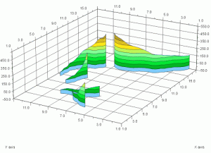
3D Cross-Sections
Straight line and Polyline cross sections can be displayed on a set of 3D axes either with or without their corresponding surface.
Animation
Animation sequences can be both displayed and exported using facilities within GINOSURF. Utilising OpenGL display lists via the GINO segment facilities, smooth rotated views of shaded surfaces can be displayed as part of an application under Windows. Alternatively, sequences of metafiles can be exported to construct animation applets using all the power of GINOSURF.
Additional Features
Export maps to DXF, WMF, CGM, BMP, JPG, PNG and Postsript formats
Print to any Windows printer or plotter
Import DXF polymesh into vertex and triangle arrays
Combine any number and any type of map on a single page
Full screen cursor or mouse interaction for data and point enquiry
Define custom line styles and colors and save for use on other maps
Add Text anywhere on the map using TrueType fonts
Include superscripts, subscripts and Greek or other characters in text
Easily clip boundaries or posted points to contour map limits
Display and print subsets of completed maps, complete with subset axes